Ground control for
1:150,000 scale aerials, Greenland
Reference systems
in Greenland
Triangulation
More than 6000 points have been surveyed in Greenland, mainly using
terrestrial methods. At a few of these points, astronomical observations were
made to locate the reference system in relation to the centre
of the earth.
Mean sea level measurements
Elevation in Greenland has historically been determined
from local observations of mean sea level. As a result, every town and
settlement has its own local height datum. In total 200 to 300 measurements of
varying quality and length were carried out. Tide was typical observed on rocks
or rock walls from periods of a few hours to a couple of weeks. The longest
series were measured in harbours.
Later, but still before GPS was introduced, the terrestrial net was
supplemented with Doppler measurements using the satellite based navigation
system Navy Navigation Satellite System (NNSS) also known as NAVSAT or TRANSIT.
Together with the Doppler measurements, the WGS72 system was introduced.
This system was later replaced with NAD83g. In this context NAD83g is the same
as NAD83(North American Datum 1983) and is the
adaption of WGS84 in Greenland.
Definition of NAD83g
Topographic and cartographic works in Greenland in the years 1978 to
1987 required all ice-free parts of Greenland to be covered by aerial
photographs in scale 1:150,000. An aerotriangulation
using these photographs resulted in the extension of NAD83g to all parts of
Greenland.
Definition of GR96
In the 1990s the need for a more
accurate reference system in Greenland became evident through the common use of
GPS. Thus the new reference system REFGR was established. This reference
network is measured using GPS and defines the official geodetic reference
system in Greenland. GR96 is based on the global reference frame ITRF
(International Terrestrial Reference Frame, ITF94). GR96 covers Greenland in
its entirety.
In winter, 2006 all Doppler observations included in the first aerotrinagulation were recalculated, new were added and the
aerotriangulation was recalculated, resulting in
coordinates in the new datum GR96.
Coordinate lists
for Greenland mapping projects
Coordinatelists in GR96 datum:
- All_coor_geo_GR96.zip (download zipfile)
- All_coor_u22_GR96.zip (download zipfile)
- All_coor_u24_GR96.zip (download zipfile)
Coordinatelists in NAD83g datum:
- All_coor_geo_NAD83g.zip (download zipfile)
- All_coor_u22_NAD83g.zip (download zipfile)
- All_coor_u24_NAD83g.zip (download zipfile)
Formats:
Coordinate list - Geographic in the format
Station Number, Latitude DDMMSS.SSSSS, Longitude DDMMSS.SSSSS, Altitude mmmm.mmm
Do not put too much emphasize on the fractions parts.
Using only the integers make sense
Output Coordinate System: Geographical coord +
MSL Heights
........Datum...........: World Geodetic System 1984
........Ellipsoide......: WGS84 or GR96
Coordinate list - UTM zone 22 in the format
Station Number, Northing m mmm mmm.mmm, Easting mmm mmm.mmm, Altitude m mmm.mmm
Do not put too much emphasize on the fractions parts. Using only the integers
make sense
Output Coordinate System: UTM zone 22 coord +
MSL Heights
........Datum...........: World Geodetic System 1984
........Ellipsoide......: WGS84 or GR96
Coordinate list - UTM zone 24 in the format
Station Number, Northing mmmmmmm.mmm, Easting mmmmmm.mmm, Altitude mmmm.mmm
Do not put too much emphasize on the fractions parts. Using only the integers
make sense!
Output Coordinate System: UTM zone 24 coord +
MSL Heights
........Datum...........: World Geodetic System 1984
........Ellipsoide......: WGS84 or GR96
Image coordinates for photostations
(observations)
File containing all observations for the 1:150,000 scale imagery: All_photoobs.zip (download zipfile)
Camera
calibrations
Download camera
calibration documents as pdf files (700 - 900 kBytes
each):
1978 - 1981 - 1985 and 1987
NB! 1987 - error in camera constant (focal
length) annotation - Read notification
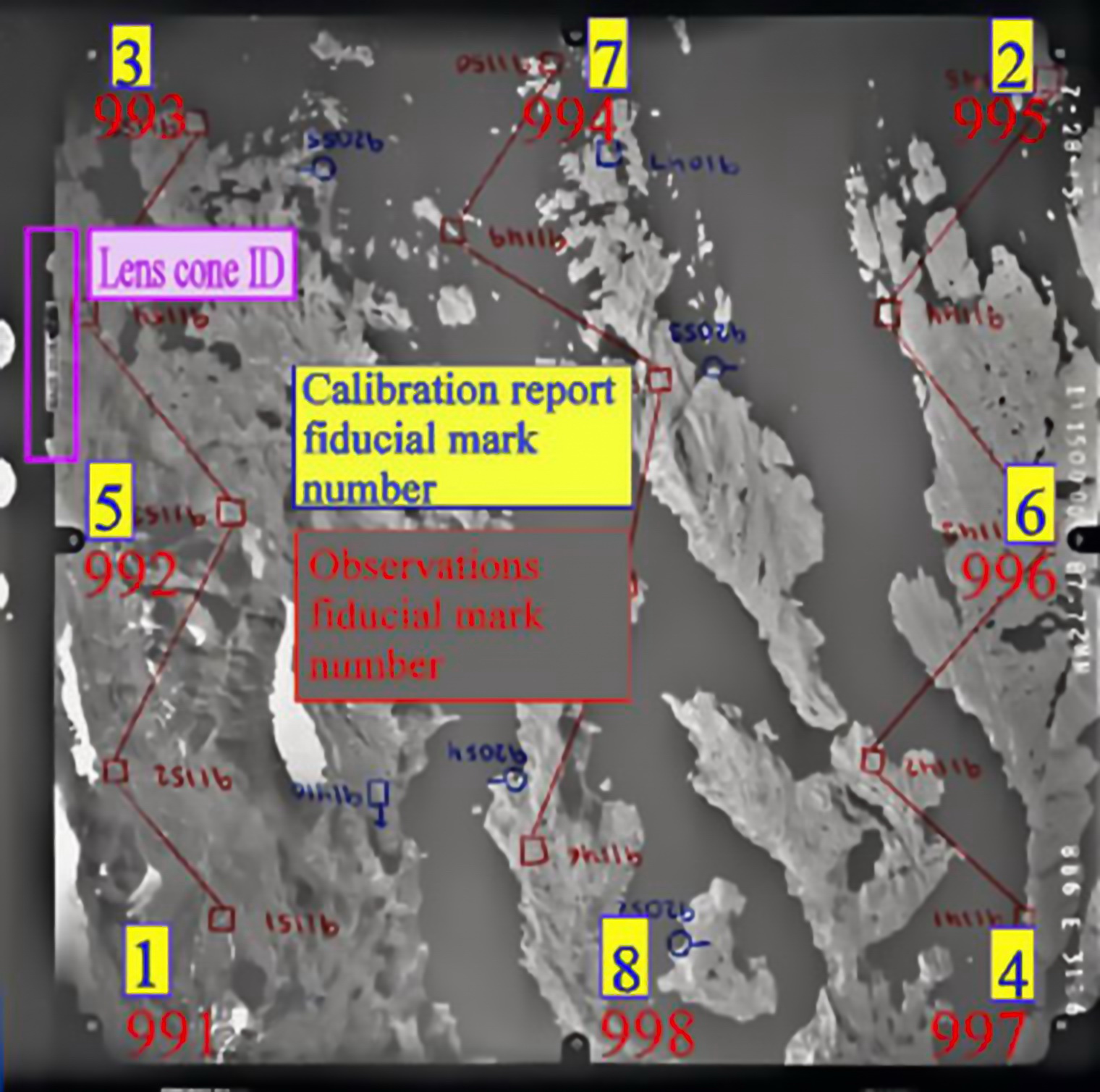
Match camera calibration fiducial mark numbers with observation file fiducial mark numbers:
http://zajt.dk/coorweb/web_eks_lille.jpg
Guide lines for
observation file
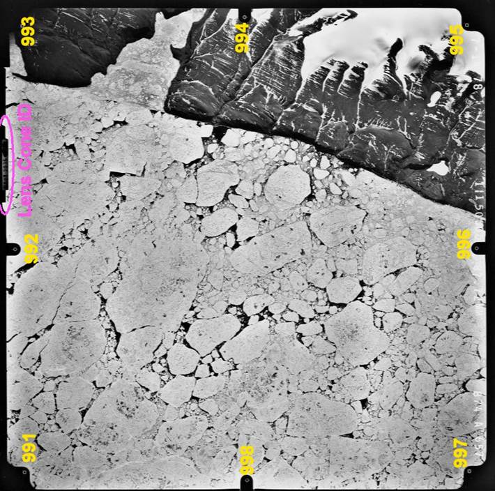
Inner orientation is defined by the physical location of fiducial marks 991 thru 998
relative to the lens cone identifyer (not to the
annotation printed on the film).
If you place the camera with the lens cone ID to the left,
you will have Fiducial mark number
991 in the lower left corner
992 in the middle left
993 in the upper left
994 in the upper middle
995 in the upper right
996 in the middle right
997 in the lower right and
998 in the lower middle
Example of from the photo observation list
* Observations from kmsgeo 9. Aug. 2001, 14.22 page 1 ;
#GR_monoDacl xxx
P0874A0657 a
78 07 14 2035 0.087724 m
MFC 0.020 mm
M1601 81 06
25 AF
F991___-106.014
mm -106.002 mm
F992___-110.008
mm ___0.002 mm
F993___-106.001
mm _105.990 mm
F994_____-0.018
mm _109.982 mm
F995____105.972
mm _105.987 mm
F996____109.984
mm __-0.005 mm
F997____105.982
mm -105.993 mm
F998_____-0.012
mm -110.006 mm
F12614___42.570
mm __43.951 mm
F16034___86.754
mm __33.264 mm
F16035__107.101
mm __59.673 mm
F16036___74.630
mm __56.370 mm
F16037___98.163
mm __97.777 mm
F16038___26.991
mm __57.258 mm
F16039___47.007
mm __86.466 mm
F16040__-13.117
mm __68.947 mm
F16041__-11.088
mm _100.887 mm
F16042__-14.094
mm __58.109 mm
Disclaimer
Geodatastyrelsen
cannot be held liable for any contents on this web site nor for any damage
caused by its rightful or wrongful usage.
Historic coordinates used
for map production prior to 2005-01-01
Coordinate
list - Geographic in the format
Station Number, Latitude DDMMSS.SSSSS, Longitude DDMMSS.SSSSS, Altitude mmmm.mmm
Do not put too much emphasize on the fractions parts.
Using only the integers make sense! Download zipfile
Output Coordinate System: Geographical coord + MSL
Heights
........Datum...........: World Geodetic System 1984
........Ellipsoide......: WGS84
Coordinate
list - UTM zone 22 in the format
Station Number, Northing m mmm mmm.mmm, Easting mmm mmm.mmm, Altitude m mmm.mmm
Do not put too much emphasize on the fractions parts. Using only the integers
make sense! Download zipfile
Output Coordinate System: UTM zone 22 coord + MSL
Heights
........Datum...........: World Geodetic System 1984
........Ellipsoide......: WGS84
Coordinate
list - UTM zone 24 in the format
Station Number, Northing mmmmmmm.mmm, Easting mmmmmm.mmm, Altitude mmmm.mmm
Do not put too much emphasize on the fractions parts. Using only the integers
make sense! Download zipfile
Output Coordinate System: UTM zone 24 coord + MSL
Heights
........Datum...........: World Geodetic System 1984
........Ellipsoide......: WGS84
Each text file is about 1.5 mbytes
(zipfile: 500 kbytes)